September 02, 2021| Community, Environment, Safety
By: Holly Odgers
Lake Hopatcong is the largest freshwater body in New Jersey. Originally two separate lakes known as Great Pond, which stretched between just north of Nolan's Point and Point Pleasant, and Little Pond, a small body of water in the area we know today as Woodport or Lake Forest, the lake was first dammed in the 1750s and was raised two additional times to reach the lake we know today in the 1840s.
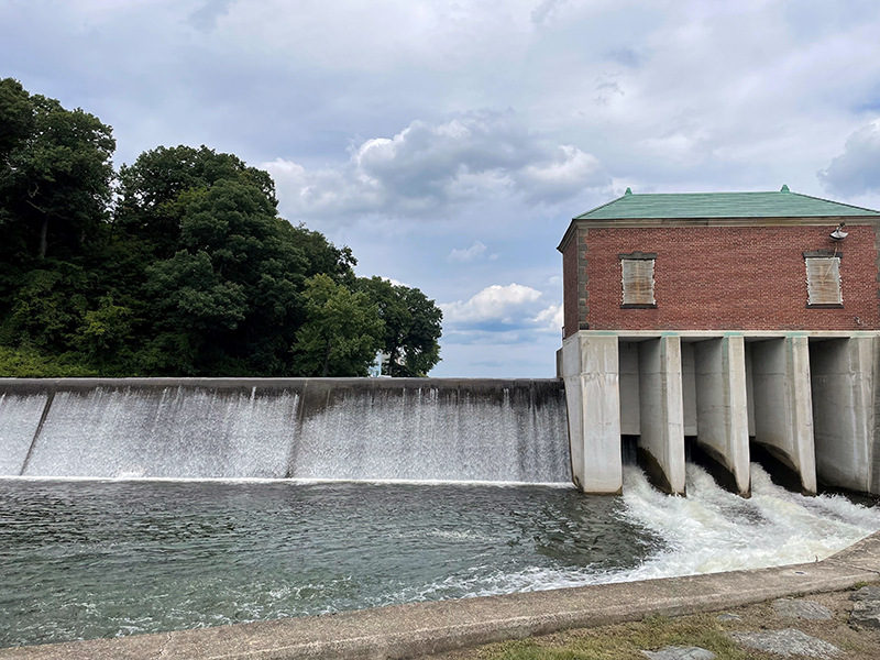
The dam at Hopatcong State Park is still used today to control the level and outflow of the lake, releasing water from Lake Hopatcong into the Musconetcong River. Under agreements reached at the time the Morris Canal was abolished, there must be a minimal outflow to maintain the Musconetcong River and watershed.
The New Jersey Department of Environmental Protection (NJDEP) funds the operation and maintenance of gages on Lake Hopatcong at the outflow into the Musconetcong River (the dam at Hopatcong State Park) through an agreement with the U.S. Geological Survey (USGS).
The USGS links below provide real-time data on the lake level, outflow into the Musconetcong River, and precipitation.
The water level on Lake Hopatcong determines when there is a no-wake restriction on the lake, based on Lake Hopatcong boating regulations.
In accordance with the state's boating regulations set forth in the New Jersey Administrative Code, a no-wake condition occurs on Lake Hopatcong when the water level "reaches the Extreme High Water Level (Elevation 924.20 feet) or when the gauge at the dam in Hopatcong State Park reads 9.5'." The wake restriction is removed when the water recedes below 9.5'
Yes! If you would like to be alerted by text or email when the water level exceeds 9.5 feet (or any level you choose), go to the U.S. Geological Survey (USGS) lake level gage site. Click "Subscribe to WaterAlert" beneath the graph. Enter your information, with desired parameters, into the form and make sure to confirm the email sent after you click submit.
“No wake” means vessels are expected to travel at the slowest speed possible while still maintaining steerage to minimize wake.
The no-wake restriction when the water level exceeds the 9.5’ high-water mark, goes into effect to prevent property damage. When vessels travel at high speeds, they create wakes. These wakes become rolling waves that make their way to the shoreline where they can potentially damage docks, boats, and property
Law enforcement on Lake Hopatcong enforces all boating regulations.
Hopatcong State Park personnel, through the NJDEP Division of Parks and Forestry, manage the lake level as outlined in the 2024 Lake Hopatcong Water Level Management Plan. Annual precipitation also affects the raising or lowering of the lake.
The winter drawdown initiation dates are determined by assessing rainfall and current lake levels. Hopatcong State Park officials initiate the drawdown as necessary to meet the 22-inch target, or a gage height of 7.16 feet, by December 15. The graph below displays the timeline and water level targets for the drawdown process.

The water level will then be maintained until a spring thaw has softened the ice on the lake sufficient to avoid ice damage to private property. Once the spring thaw is underway, the flow will be reduced at the dam to a level to both maintain sufficient flow to the Musconetcong River and allow refill of the lake, given adequate rainfall, to the elevation of 9 feet.
Every five years, the New Jersey Department of Environmental Protection (NJDEP) lowers the water level on Lake Hopatcong by 60 inches (5 feet), to allow for inspection and repairs to shoreline structures including the dam at Hopatcong State Park. Residents can contact their municipal town hall and Hopatcong State Park (973-398-7010) to inquire about needed permits for work on waterfront structures.
The next planned 5-foot drawdown is scheduled for 2028.
The timing of the drawdown is intended to allow for repairs before winter weather sets in, with the refill beginning early enough to reduce the likelihood of impact on the lake’s water level the following boating season.
According to NJDEP’s 2024 Lake Hopatcong Water Level Management Plan, the target date for the lake to fully drop 60 inches (5 feet) is November 1, with a drawdown rate of 1.5 inches per day. If the lake level is at 9 feet, the drawdown will begin on September 22. That date of initiation will be adjusted based on the water level reading at the Hopatcong State Park dam, with the start date adjusted one day earlier or later for each 1.5-inch deviation from the 9-foot mark. The rate of drawdown shall be adjusted to account for rainfall throughout the drawdown period in order to reach a water elevation in the lake of 4 feet (60 inches, or 5 feet, below the crest of the dam at 9 feet) by November 1.
The lake will remain at the 60-inch (5-foot) drawdown level from November 1 to December 15. After that, the refill will begin and continue until the annual 22" drawdown level is reached (as indicated in Appendix E of the 2024 Lake Hopatcong Water Level Management Plan) or until ice forms. It will remain at this level until it is determined that the spring thaw has softened the ice on the lake sufficiently enough to avoid ice damage to private property, at which point, the lake shall be allowed to fill to the crest of the dam at 9 feet.
 |
| Source: 2011 Lake Hopatcong Water Level Management Plan |
The goal of the Lake Hopatcong Water Level Management Plan is to “protect the environmental health and the natural and scenic resources of Lake Hopatcong/Musconetcong River System, maximize recreational opportunities, minimize the potential for damage to property and waterfront structures, while maintaining the minimum flow requirements necessary to protect downstream uses, including but not necessarily limited to: aquatic biota, historic resources, and water quality.”